WP-2: Glacier melt and discharge
In polar regions, glacier retreat is a crucial parameter in environmental studies since new ice free areas are formed that enable colonisation and the development of new communities. Moreover, this can also affect the aquatic systems and is regarded as an indicator of climate change.
Spatio-temporal dynamics of glacier melt on KGI (IP-2)
Ulrike Falk (Center for Remote Sensing of Land Surfaces (ZFL), Germany); Matthias Braun (University of Erlangen, Germany)
The main objectives of this study are the quantification of hydrological and geophysical processes of Potter Cove Glacier, its energy and water exchange with the atmospheric boundary layer as well as melt water production and glacier mass balance under the impact of climatic change.
We will start an extensive field programme on Potter Glacier in November this year in addition to previous observations on Bellingshausen Dome and the main ice cap of King George Island. The observations on Potter glacier shall be run over three years and comprise the installation of automated micrometeorological and photogrammetric measurements including direct measurements of surface energy fluxes on the glacier. Additionally snow courses and mass balance stakes will be placed on the glacier and differential GPS measurements will be performed regularly.
The measurements and historic climate data records will form the base for glacier mass balance and melt modelling. TerraSAR-X satellite data will be used to map glacier retreat, i.e. changes in glacier extent and snow covered areas. The remote sensing data serves as a platform to spatially validate the glacier melt modelling. Different weather patterns will be analyzed with regard to their impact on glacier melt rates. The snow courses and modelling activities shall cover Potter Peninsula in order to link them to the hydrological and sedimentological measurements and other research work.
KGI glacier discharge dynamics (IP-3)
Carmen Dominguez (USAL, Spain); Adolfo Eraso (UPM, Spain)
- Provide hourly time series of glacier discharge at Maxwell Bay (Potter Cove) in KGI. This station is working currently and generating hourly time series – continuously since January 2002 – of glacier discharge (actual time series yet with more than 60.000 values)
- Establish the equation that quantifies discharge evolution along time
- Differentiate the annual discharge wave, the aftershocks and drainage threshold in the annual hydrograph from the experimental catchment area
- Study the influence of different meteorological variables on glacier drainage from spectral and correlation analysis and wavelet analysis, which give interesting information about the behaviour of glaciers as drainage systems.
- Quantify the contribution rate of solid sediments (turbidity) at Potter Cove in present time, to estimate the variation of solar radiation in marine ecosystems and geochemical characteristics of discharged waters (Eh-pH curves), water temperature and conductivity, to find out the hydrolysis capacity in subglacier rocks and their possible generation of nutrients.
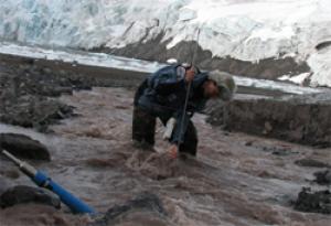
 Measuring glacier discharge. Photograph by GLACKMA |
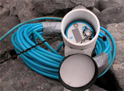
 Data logger. Photograph by GLACKMA |

