Completing the field work
After finishing the sidescan and grab-sampling programs, today, we went out to also finish the seismic work.
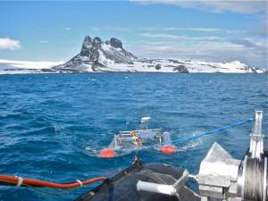
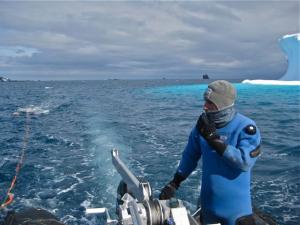
Blue sky and a smooth sea surface invited us and we started to prepare the gear in the morning. The subbottom profiler itself with the transducer mounted on a catamaran, computers, GPS, cables and the power generator had to be checked and the set-up drill had to be performed. There is no space on the zodiac and it is wet so you better know in advance which box must go to which place in which order and which cable connects which parts of the system. Fortunately, we can always count on the help of the divers Jorge, Gastón and Fabien and the overwintering biologist Ariel to help us carrying the heavy boxes. Most of the times Gastón was driving our boat and keeping it on track, even though the asymetrically towed catamaran tried continuously to tear the boat in all other directions. Today, there was no problem with the weather but problems with small ice bergs and ice floes that always tried to get in front of the catamaran to block it and to produce some extra noise in the data. Additionally, a bigger iceberg decided to plough its way through the sediments of Potter Cove blocking as many of our transect lines as possible. In the end, all went well and we recorded some 10 nautical miles of seismic profile data.
The seismic investigations shall provide an insight into the subbottom sediment structures and geometries of Potter Cove. These data are instrumental in reconstructing the younger depositional history of the area that appears to react sensitively to climate change. Furthermore, the data are able to link seismically visible features of a number of sediment cores that were taken earlier in this area in the frame of IMCOAST, thus translating the vertical sediment-core information laterally into space.
 |
 |

